CATS

The Cloud-Aerosol Transport System (CATS), launched in January of 2015, is a lidar remote sensing instrument that will provide range-resolved profile measurements of atmospheric aerosols and clouds from the International Space Station (ISS). CATS is intended to operate on-orbit for at least six months, and up to three years.

Project Overview

The CATS payload is designed to provide a combination of long-term operational science from the ISS, in-space technology demonstration for future Earth Science missions, and build-to-cost, build-to-schedule development approach. CATS is not a "business as usual" project - it is specifically intended to demonstrate a low-cost, streamlined approach to developing ISS science payloads. The instrument consists of many new features compared to previous and current space-based cloud-aerosol lidars, such as a high repetition rate laser with photon counting detection, multiple beams, and a seeded laser for high spectral resolution lidar (HSRL) capabilities.

CATS data are used to derive properties of cloud/aerosol layers at two wavelengths (532, 1064 nm) including:

  • backscatter
  • depolarization ratio
  • layer height
  • layer thickness
  • extinction
  • depolarization-based discrimination of particle type

These data products are used for assimilation into aerosol transport models, as complementary datasets to the NASA A-Train sensors, and to maintain continuity in the global lidar climate record.

CATS Principal Investigator Dr. Matt McGill discusses the CATS project.

Utilizing the ISS

The instrument is located on the Japanese Experiment Module – Exposed Facility (JEM-EF) on the International Space Station (ISS). ISS provides a low-cost platform for earth science capabilities and instantaneous data downlinking with loss of signal (LOS) periods that last 30-45 minutes

On 22 Jan. 2015, CATS was installed on the JEM-EF and powered on. The CATS team watched as the instrument successfully sent health and status data to GSFC for the first time.

An artist’s rendering of CATS operating aboard the ISS.

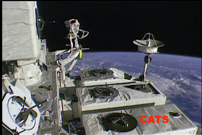
The CATS instrument, highlighted by the red arrow, is currently operating on the JEM-EF.

The ISS orbit provides more comprehensive coverage of the tropics and mid-latitudes than sun-synchronous orbiting sensors, with nearly a three-day repeat cycle. As a result, CATS provides comprehensive coverage of the tropics and mid-latitudes, where the primary aerosol transport paths are located. Additionally, the irregular orbit of the ISS permits study of diurnal changes in clouds and aerosols.

The ISS orbit is a 51-degree inclination orbit at an altitude of about 415 km.

The CATS Instrument

Primary design considerations for the Cloud-Aerosol Transport System include:

  • Make the system as eye-safe as possible.
  • Use solid state photon-counting detectors.
  • Leverage existing instrument designs and use commercial parts where possible.
  • Fit within mass, volume, and power constraints of the JEM-EF.

In recent years there have been significant advances in the approach to lidar design. A now-proven approach to lidar design is to use a high PRF laser, multiple kHz rather than 10's of Hz, at low pulse energies. Ground based systems of this type, the MicroPulse Lidar, have been in use since the early 90's. The airborne Cloud Physics Lidar has been used since 2000. The advantages of the high PRF design with low per-pulse energy permits use of solid-state photon-counting detectors. A basic requirement of the high PRF approach is a narrow field of view (along with narrowband filtering) to minimize solar background noise. The narrow FOV minimizes multiple scattered signals.

The overall instrument design is driven by the desire to use photon-counting detection. The system transmits three wavelengths (1064, 532, and 355 nm) simultaneously and collinear. Return signal collected by the telescope is separated by use of dichroics. The return signals are further separated into polarization components.

The laser units are provided by Fibertek, Inc., as is the avionics/communications package. Mechanical design services are provided by Design Interface, Inc. The Fabry-Perot interferometer in the HSRL receiver was provided by Michigan Aerospace Corporation.

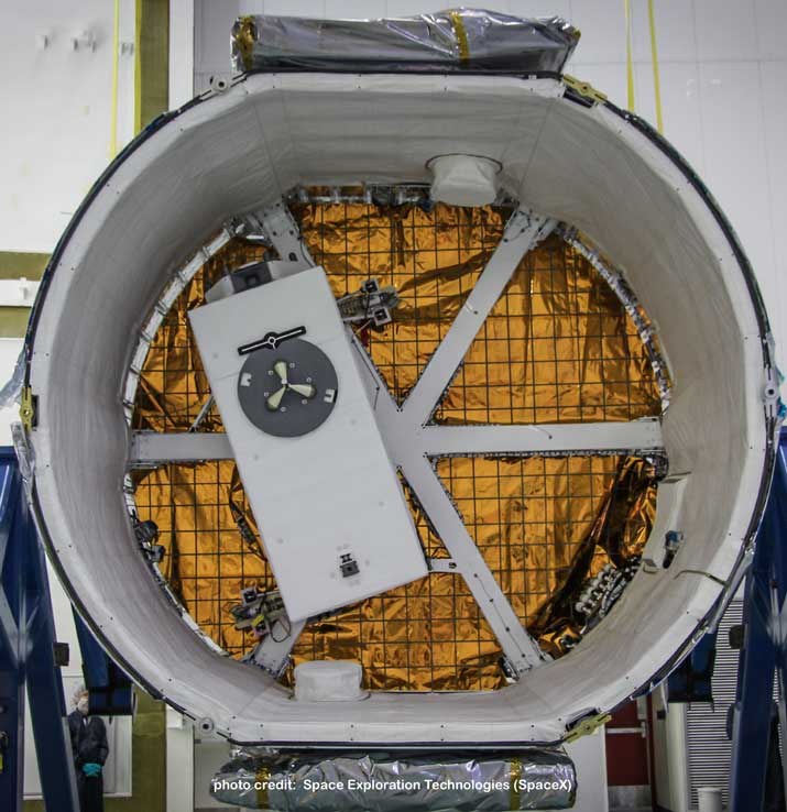
On 30 Sept. 2014 CATS left NASA GSFC for SpaceX facilities at Cape Canaveral, where it arrived a day later. CATS installation on the SpaceX dragon capsule was completed on 08 Oct.

The CATS instrument was fully assembled and tested in the CATS clean room at NASA GSFC

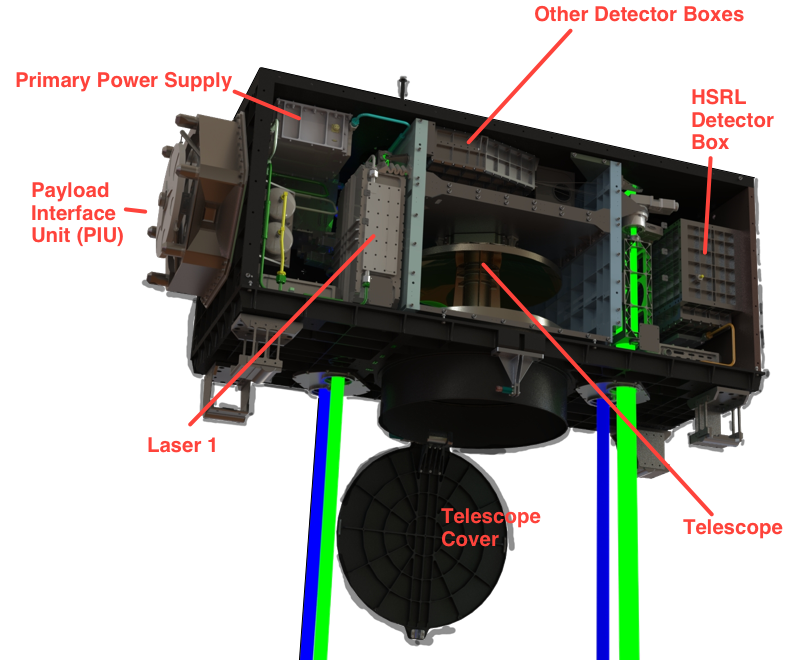
A schematic of the CATS instrument and subsystems

A closer look at the CATS instrument as it orbits the earth aboard the ISS.

CATS Videos

Below are selected videos from the NASA Goddard Scientific Visualization Studio


The ISS passes over a plume of ash and sulfur dioxide (SO2) from the Calbuco Volcano eruption. The volcano plume can be seen in attenuated backscatter data collected by the CATS instrument, onboard the ISS.

The ISS passes over a region of wildfires in Oregon. Smoke from the wildfires can be seen in attenuated backscatter data collected by the CATS instrument, onboard the ISS.

Science Goals

The measurements of atmospheric clouds and aerosols provided by the CATS payload will be used for three main science objectives:

  1. Provide near real-time (NRT) observations of aerosol vertical distribution as inputs to global models. The vertical profile information obtained by CATS, particularly at the 1064 nm wavelength and with depolarization information obtained in Modes 1 and 2, provides height location of cloud and aerosol layers, as well as information on particle size and shape. Using the instantaneous data downlinking of the ISS, CATS data products are produced within 6 hours of collection and sent to aerosol forecasting groups to be assimilated into models.
  2. Extend the space-based lidar record to different local times of day. The CATS instrument will provide measurements of cloud and aerosol profiles similar to CALIPSO, but at different local times each day compared to CALIPSO. Thus, CATS fills in the data gap between the twice-daily CALIPSO measurements so this information can be used to improve our understanding of the diurnal effects of clouds and aerosols. Additionally, heritage data products are produced to provide continuity in the global lidar data record.
  3. Advance technology in support of future space-based lidar mission development by demonstrating the ability to retrieve vertical profiles using a high rep rate laser and photon counting detection, multiple beams, and a seeded laser.

CATS Modes of Operation

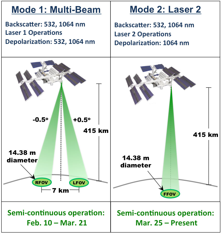
To meet these three science goals, CATS operates in two different modes using three instantaneous fields of view (IFOV):

Mode 1 Multi-beam backscatter detection at 1064 and 532 nm, with depolarization measurement at both wavelengths.
Mode 2 Demonstration of seeded laser, with standard backscatter and depolarization measurements at 1065 nm.

Publications

Contact Us

For information about the Cloud-Aerosol Transport System, status, or data availability please contact the CATS group.

The Principal Investigator and Payload Developer for CATS is Dr. Matthew McGill.

Dr. Matthew McGill

Instrument & schedule
Phone 301-614-6281
Fax 301-614-5492
Email Matthew.J.McGill@nasa.gov

Dr. John Yorks

Science capabilities, data products
Phone 301-614-6284
Fax 301-614-5492
Email John.E.Yorks@nasa.gov

Mr. Dennis Hlavka

Data processing & availability
Phone 301-614-6278
Fax 301-614-5492
Email Dennis.L.Hlavka@nasa.gov